A bit of history…
Since the early days of maritime navigation, various methods have been introduced to facilitate travel across long and vast seas. Various traditional practices, using geometry, astronomy and even special instruments, helped sailors navigate to their destinations over a fairly long period.
The nautical mile emerged as a practical development of navigation. The concept of parallels of latitude and meridians of longitude was developed during the 16th century. This form of navigation was sought as an alternative to visual navigation.
The nautical mile is therefore based on latitude and longitude. They are mathematically linked to the circumference of the earth and to latitude and longitude. This unit of measurement is used by all nations for air and sea travel.
Why use a different measurement system for maritime navigation?
The use of latitude and longitude coordinates is more practical for long distance travel, where the curvature of the Earth becomes a factor in precise measurement.
Nautical charts use latitude and longitude, so it is much easier for navigators to measure distance with nautical miles.
Air and space travel also use latitude and longitude for navigation and nautical miles to measure distance.

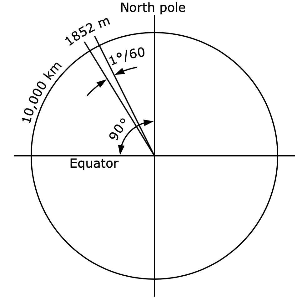
As we can see in the picture, the nautical mile is based on the circumference of the planet Earth. If you were to cut the Earth in half at the equator, you could take one of the halves and see the equator as a circle. You could divide that circle into 360 degrees. Then you could divide one degree into 60 minutes. One minute of arc on planet Earth is 1 nautical mile.
Nautical miles are used to measure the distance travelled across water. It is based on the longitude and latitude coordinates of the Earth. One nautical mile is equivalent to one minute of latitude”.
Nautical mile and knots
A knot is a measure of speed, which is simply equivalent to one nautical mile per hour. This measurement is still standard in maritime and air navigation, along with the use of nautical miles.
The name “knot” derives from early maritime practices for measuring speed. This was a regularly spaced knotted rope tied to a piece of wood. This wood was placed in the water behind a ship, and the length of the rope (in knots) passing behind the ship over a given period of time determined the speed.
How is the nautical mile and the knot calculated?
One knot equals one nautical mile. However, the nautical mile measures the distance and the knot measures the speed”.
The nautical chart becomes one of the most important elements on the outside of the vessel once it sets sail. The fixed relationship between distance, speed and time helps mariners calculate the distance the ship is expected to travel in a given time.
1 knot = 1 nautical mile per hour = 1852 m/h (metres per hour). That is approximately 0.5144 metres per second.
The formula used is 60 x D = S x T, which is expressed as 60D = ST.
Nautical mile and metre
In 1929 the International Hydrographic Organisation officially standardised the nautical mile against the metre. It was established that one nautical mile was equivalent to 1,852 metres. The United States and the United Kingdom used slightly different measurements for some time, but they are now all standardised.
How to convert kilometres to nautical miles
The following video tutorial explains very easily how to convert kilometres to nautical miles, along with an example and the formula to follow.
Comparison of the nautical mile with land distances
The nautical mile is 1852 m, which is longer than the land mile we usually use on land. A land mile is 1609 m, which in turn is longer than a kilometre of 1000m.
Nautical Mile = 1852 m
Statute mile = 1609 m
Kilometre = 1000 m
1852 m may seem like an arbitrary distance, but it is not. It is mathematically linked to the size of the planet, being 1/60th of a degree of longitude along the equator.

Who uses the nautical mile today?
The maritime industry is not alone in its use of the nautical mile. The aviation and space industries also use nautical miles as a measure of distance. When you look at the similarities between them and the maritime industry, it becomes clear why. All three navigate on a global scale. Courses and distances follow spherical trajectories referenced to the earth’s surface.
Aircraft and spacecraft also use knots to measure their speed. As in the maritime version, knots only measure nautical miles per hour.
Although no longer in the nautical domain, navigation techniques remain the same.


